FAQs
3,700 Daily Deaths
Every single day, 3,700 people die on the world's roads. Vulnerable road users account for more than half of all fatalities.


Based on the specific accuracy metrics mentioned (98.7% accuracy), the product appears to be fully developed and potentially in deployment or pilot phase. However, without case studies, client testimonials, or deployment information visible on the website, the exact commercialization status is unclear.
Similar AI pothole detection systems like San Jose's pilot project have achieved 97% accuracy for potholes and 88% accuracy for debris detection, suggesting AT Folks' claimed accuracy is competitive with deployed municipal systems.
Annual Road Fatalities Globally
Serious Injuries Each Year
Accidents Caused by Human Error
ROI for Every $1 Invested
Every year, 1.35 million people lose their lives in road traffic crashes globally, with over 50 million suffering serious injuries.
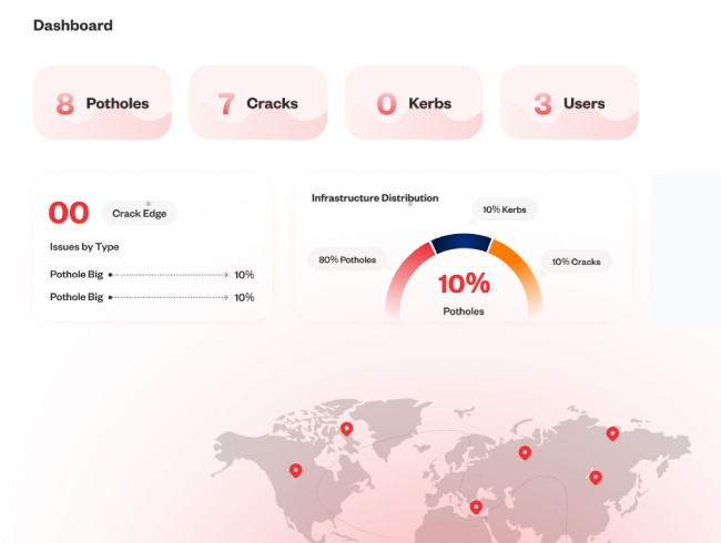
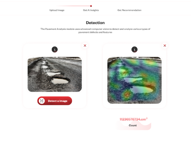
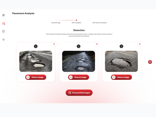
Advanced algorithms process millions of images to detect infrastructure defects and monitor traffic patterns automatically.
ML models analyze data to predict accident-prone areas before crashes occur with unprecedented accuracy.
Continuously monitor road conditions, detect drowsy drivers, and identify traffic conflicts before accidents.
AI-powered optimization that adapts to real-time traffic flow and prioritizes emergency vehicles automatically.
Aggregate data from CCTV cameras, traffic sensors, vehicle sensors, dashcams, smartphones, historical crash data, weather conditions, and street view images.
Computer vision extracts features from images, machine learning identifies patterns, predictive analytics forecast risks, and deep learning classifies objects and behaviors.
Generate comprehensive safety assessments with risk maps, star ratings, probability scores, priority rankings, and cost estimates for recommended improvements.
Alert drivers to hazards, trigger automatic safety responses, notify traffic management centers, adjust signal timing dynamically, and deploy emergency services.
Machine learning ensures constant enhancement. Models learn from new data daily, accuracy improves with every interaction, and the system adapts to local conditions.
450K
Lives saved annually when deployed globally
40-60%
Reduction in accident rates in pilot deployments
Pilot deployments typically take 1-3 months. Full city-wide implementations range from 3-6 months depending on scale. We provide a phased approach with immediate value delivery from day one.
We work with existing cameras and sensors in most cases. For optimal performance, we recommend HD cameras with 30fps capability. Our platform is designed to integrate seamlessly with your current infrastructure.
We use privacy-preserving techniques including temporary capture, encrypted transmission, and no permanent storage of identifiable images. Our system is fully GDPR compliant and respects all data privacy regulations.
Our risk prediction models achieve 85-92% accuracy depending on data quality and conditions. Accuracy improves over time as the system learns from new data and local patterns.
Yes, we offer APIs and standard protocols for integration with most traffic management systems. Our team works closely with your IT department to ensure seamless integration.
The system automatically triggers alerts to relevant authorities and can activate connected safety systems like variable message signs or traffic signals. Response time is typically under 2 seconds.
Join 500+ organizations worldwide using AI to save lives and reduce accidents. Get started today with a free consultation.